Hawaii

Hawaiian Archipelago

Aloha everyone,

As 2020 comes to an end, we wanted to present the preliminary report by Dr. Marc Lammers of our Wave Glider Mission through the PMNM.

Have a safe and joyous holiday!

“November 6, 2020

Dr. Marc Lammers, Research Coordinator at NOAA's Hawaiian Islands Humpback Whale National Marine Sanctuary

This presentation describes recent fluctuations in the presence of humpback whales in Hawaiʻi over the past several years and the science being conducted to understand these trends. Dr. Marc Lammers discusses the application of novel tools to understand the occurrence of humpback whales in remote habitats, including the use of a Wave Glider and machine learning algorithms to detect the presence of whales in the Papahānaumokuākea Marine National Monument.

This presentation is part of the Kauai Ocean Discovery speaker series that is celebrating November, which is Ho`i Koholā (Return of Humpback Whale Month).”

Reference:

https://sanctuaries.noaa.gov/education/teachers/occurrence-humpback-whales-through-acoustics.html


For a look back at Europa's prior journeys, check out our MAP and the Sea Surface Temperature (SST).

Aloha!

Subscribe to our blog

Land Ho, Land Ho!

Europa has finally made it home and was safely recovered March 14th. This type of survey throughout the pristine Papahānaumokuākea Marine National Monument has been the first of its kind. We are very proud of the mission and collaboration with the Navy and NOAA Sanctuary. Thank you all for following Europa’s journey.

 
Europa’s course navigating outside of the 200’ depth contour (red circles) throughout the PMNM

Europa’s course navigating outside of the 200’ depth contour (red circles) throughout the PMNM

 
Europa lays eyes on the Kohala Coast and Mauna Kea on the Big Island

Europa lays eyes on the Kohala Coast and Mauna Kea on the Big Island

Europa with view of Mauna Kea: Land Ho!

Europa with view of Mauna Kea: Land Ho!

 
View of Europa from the May Maru

View of Europa from the May Maru

Europa, moments before recovery on the May Maru

Europa, moments before recovery on the May Maru

 
Given the current Covid-19 pandemic, Europa follows appropriate bio-security protocol

Given the current Covid-19 pandemic, Europa follows appropriate bio-security protocol

She's not sure about coming to shore after her journey in the pristine, uninhabited, PMNM. Please stay safe!

She's not sure about coming to shore after her journey in the pristine, uninhabited, PMNM. Please stay safe!

 
Recovery crew: Beth, Maya, and Jessica (from left to right)

Recovery crew: Beth, Maya, and Jessica (from left to right)


For a look back at Europa's prior journeys, check out our MAP and the Sea Surface Temperature (SST).

Aloha!

Subscribe to our blog

End of year...

Our HUMPACS project has made for an exciting and busy year. To wrap it up, Beth had the opportunity to present the results of our HUMPACS East mission at the World Marine Mammal Conference in Barcelona, Spain Dec 6-12, 2019. She presented in the session on “Assessing Marine Mammals in the High Seas” as well as in the workshop “Using smart acoustic technology to detect, classify, localize and track marine species”.

Beth presenting at the WMMC

Beth presenting at the WMMC

Beth Goodwin, Rose Fisher, Jillian Duggan, Ashley Noseworthy (left to right)

Beth Goodwin, Rose Fisher, Jillian Duggan, Ashley Noseworthy (left to right)

We have another HUMPACS mission planned for 2020! Check back in with us in January, in the mean time wishing you all a Joyful Holiday and a Happy New Year!!


For a look back at Europa's prior journeys, check out our MAP and the Sea Surface Temperature (SST).

Aloha!

Subscribe to our blog

HUMPACS East Results Are In!

We know you’ve all been waiting to hear about the success of HUMPACS East, and believe us, we’ve been just as anxious to let you all know.

Our results have just been published in the The Journal of the Acoustical Society of Amer (Vol.145, No.6).

The purpose of this study was to investigate if whales were present in the offshore waters between the Hawaii and Mexico breeding grounds where, to our knowledge, they have never been documented before. It’s a big ocean out there, so we were searching for a needle in a haystack…and we were successful!

Publication East Map.jpg

We identified humpback calls out to 1,200nm from Hawaii, approximately midway to Mexico.

Our findings raise more questions regarding humpback whale breeding grounds, migration routes, and habitat. We have presented our results to the Marine Mammal Commission and hope to present at the World Marine Mammal Science Conference in Barcelona, December, 2019. We feel certain our results will elicit more research, affect how marine mammals are monitored and help with management.

Read the Publication (link to PDF)

Supplemental Material (link to download)

Copyright 2019 Acoustical Society of America. This article may be downloaded for personal use only. Any other use requires prior permission of the author and the Acoustical Society of America. The article appeared in The Journal of the Acoustical Society of Amer (Vol.145, No.6) and may be found at https://doi.org/10.1121/1.5111970.

Below is a short annotated power point presentation of our mission and results.

Aloha!


For a look back at Europa's prior journeys, check out our MAP and the Sea Surface Temperature (SST).

Aloha!

Subscribe to our blog

Photo Time-lapses from Europa

Almost one month has passed since we recovered Europa, and we are still in the process of analyzing data, however; we have reviewed all of our photos. During the 3.5 month mission, we had a camera attached to both the top and bottom of Europa’s float that took above and underwater images periodically on a daily basis.

The top camera was mounted on the back of the float looking forward, which enabled us to inspect the float and antenna deck during the mission. The bottom camera looked down towards the sub underneath the water to help us check the sub and umbilical. In the previous blog, we mentioned we had a gooseneck barnacle that grew over the underwater camera lens. Even so, we were still able to get glimpses of the sub for diagnostic purposes.

Over the 3.5 month mission, the top and bottom mounted cameras took over 500 photos each. We have constructed two time-lapse videos of the above and underwater pictures, which are each a little over three minutes long. We were able to capture some fantastic photos! The sunset photos and waves washing over the float are captivating, and it’s fun to watch the barnacle grow over time in the underwater footage.

In our next blog, we will post some sample of audio files of some exciting sounds we’ve heard, including odontocetes whistles and clicks, echolocation, and other unusual noises. Stay tuned!


For a look back at Europa's prior journeys, check out our MAP and the Sea Surface Temperature (SST).

Aloha!

Subscribe to our blog

Land Ho!

Europa approximately 40 nautical miles off South Point (the red star).

Europa approximately 40 nautical miles off South Point (the red star).

Europa is nearing the shores of Ka Lae (ka-lie), or South Point, which is the southernmost tip of the Big Island and the United States. Archaeological excavations and Hawaiian tradition indicate Ka Lae, meaning “the point,” was the first place the early Polynesians occupied in Hawaii, as early as A.D. 124. The area is an official National Historic Landmark (NHL) because of its cultural significance and importance. Claiming this region as an NHL enables protection and preservation under the National Historic Preservation Act (NHPA).

Two prevailing currents converge off the coast of South Point: Kāwili and Hala’ea.The Kāwili, or the Hawaiian Lee Counter Current, flows from west to east all the way from Asia. This current is thought to have helped early Polynesians find the Hawaiian Islands while traveling from their original homeland: Kahiki.

The Hala’ea, also known as the North Equatorial Current, travels east to west by trade winds and is named after the greedy chief, Hala’ea. Oral histories and texts say Hala’ea ordered his men to throw all of their aku (tuna) into his canoe so he could claim all of the fish for himself. His men threw so many fish into his boat that it capsized, and he was swept out to sea by a strong current. Hence, the current bears his name.

The currents bring many nutrients and make the waters off Ka Lae abundant in fish. However, they also carry a vast amount of trash that piles up along the coastline. The majority of the waste is plastic, likely from the Great Pacific Garbage Patch carried by Hala’ea.

Since the first settlement of Polynesians, communities within Ka Lae have relied on fish as their prominent resource. In the 1950s, the University of Hawaii and the Bishop Museum excavated a site called Pu’u Ali’i. This location is thought to be one of the first dwellings in Ka Lae established by fishermen. Archaeologists found many different types of large fish hooks and tools to make them, including coral and stone abraders. Further excavations in Ka Lae revealed a fishing shrine (Ko’a) within the Kalalea Heiau. This shrine was created for the fishing god, Ku’ula, to maintain the abundance of fish. Other remaining cultural sites within the area are Lua o Palahemo, the Canoe Mooring Holes, and Lua Makalei.

The federal government manages NHL’s, and although it protects Ka Lae, it does not provide enough support on a local and state level. As environmental and cultural regimes continue to shift in Hawaii, significant stakeholders of Ka Lae (community members, the State of Hawaii, and the Department of Hawaiian Homelands) have recognized the need for additional preservation, conservation, and management efforts. Thus, since 2016, a new management plan has been underway that implements community-based management strategies of long-term land stewardship, and natural resource and cultural management.

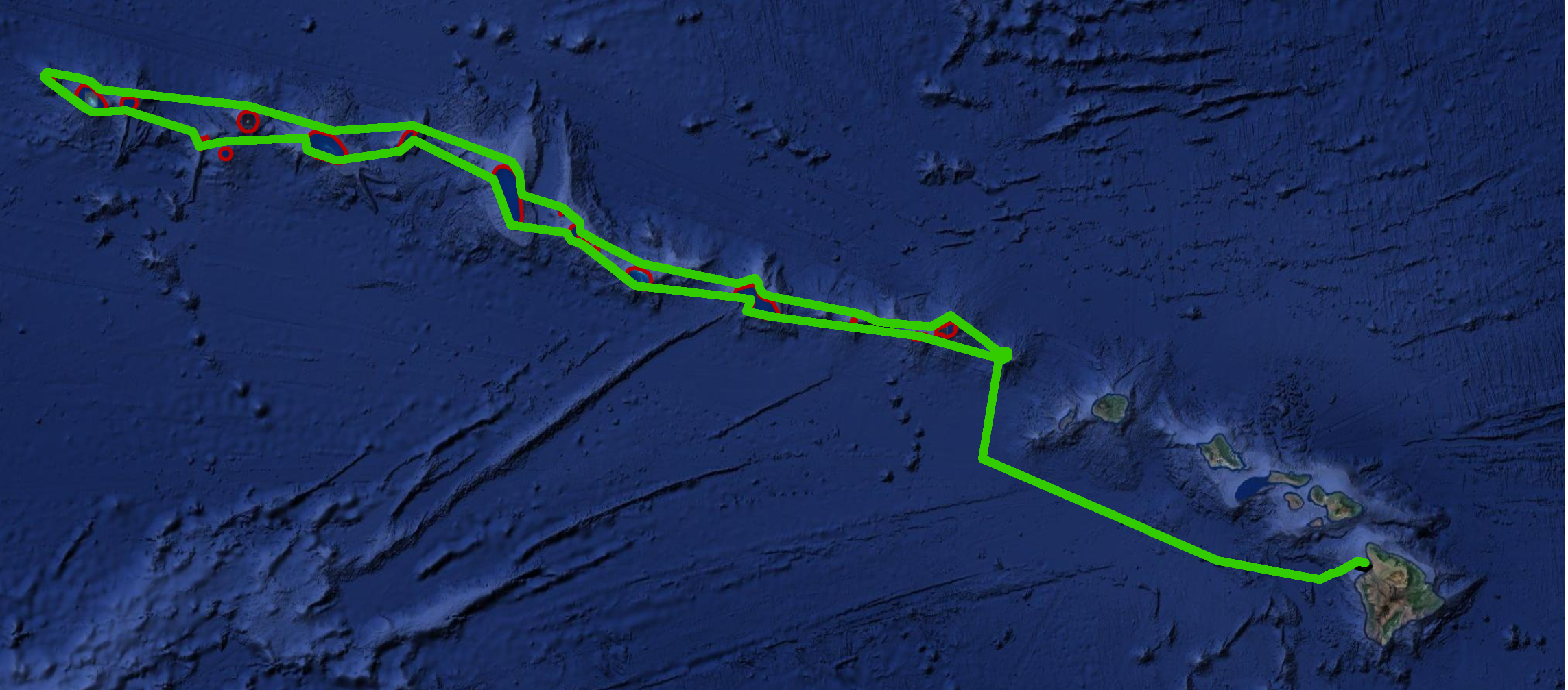
Europa was able to swim past South Point without any issues from the currents as she traveled towards Mexico. We hope she doesn’t have any trouble as she passes it once more on her way home. Once she wraps around the point and gets north of Milolii (see map above), we plan to retrieve her with our vessel, the May Maru. She has approximately 80 nautical miles to go until retrieval. Track the rest of Europa's journey on our website and stay tuned for exciting new updates after HUMPACS concludes!


For a look back at Europa's prior journeys, check out our MAP and the Sea Surface Temperature (SST).

Aloha!

Subscribe to our blog