Feelin' Groovy

Europa has completed about one-third of her voyage north as she continues to cruise across deep ocean basins between the shallow banks, islands and atolls of PMNM. We monitor her health and download audio files and pictures of the sub daily. So far, we have posted some pretty interesting audio files. Below are some pictures of Europa’s sub showing the umbilical with tension and some slack. We painted one side of the umbilical so that we can tell if it gets any twist. Looking pretty straight now!!

Europa sub (PMNM)

Europa sub (PMNM)

Europa sub (PMNM)

Europa sub (PMNM)

Meanwhile, back in Puako, we were able to capture some pretty cool pictures off our Wave Glider, Metis, which is towing a hydrophone and streaming live whale song off Puako. These are of a bottlenose dolphin swimming around the sub, perhaps just curious or trying to catch one of the many fish that hang out around the vehicle. Something very similar has likely happened to Europa while transecting the environmentally rich waters of PMNM. Our hope is to get lucky enough to capture some images like these off Europa during her voyage.

Metis sub (Puako)

Metis sub (Puako)

Metis sub (Puako)

Metis sub (Puako)

Metis sub (Puako)

Metis sub (Puako)

Metis sub (Puako)

Metis sub (Puako)

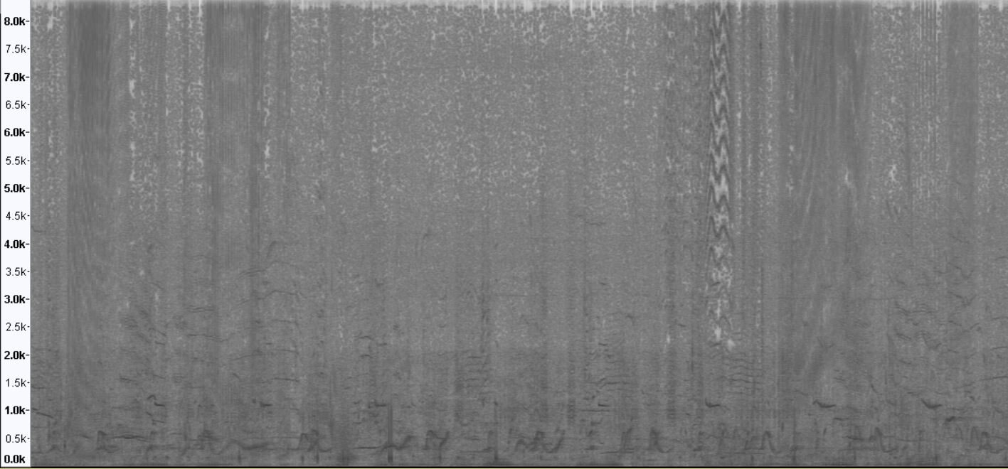
Take a look and listen to the audio we captured at the moment when the bottlenose dolphin is hanging out with Metis.

Spectrogram of audio clip belowBottlenose dolphin with humpback whales chorusing in the background

Spectrogram of audio clip below

Bottlenose dolphin with humpback whales chorusing in the background


For a look back at Europa's prior journeys, check out our MAP and the Sea Surface Temperature (SST).

Aloha!

Subscribe to our blog

Welcome to Mokumanamana

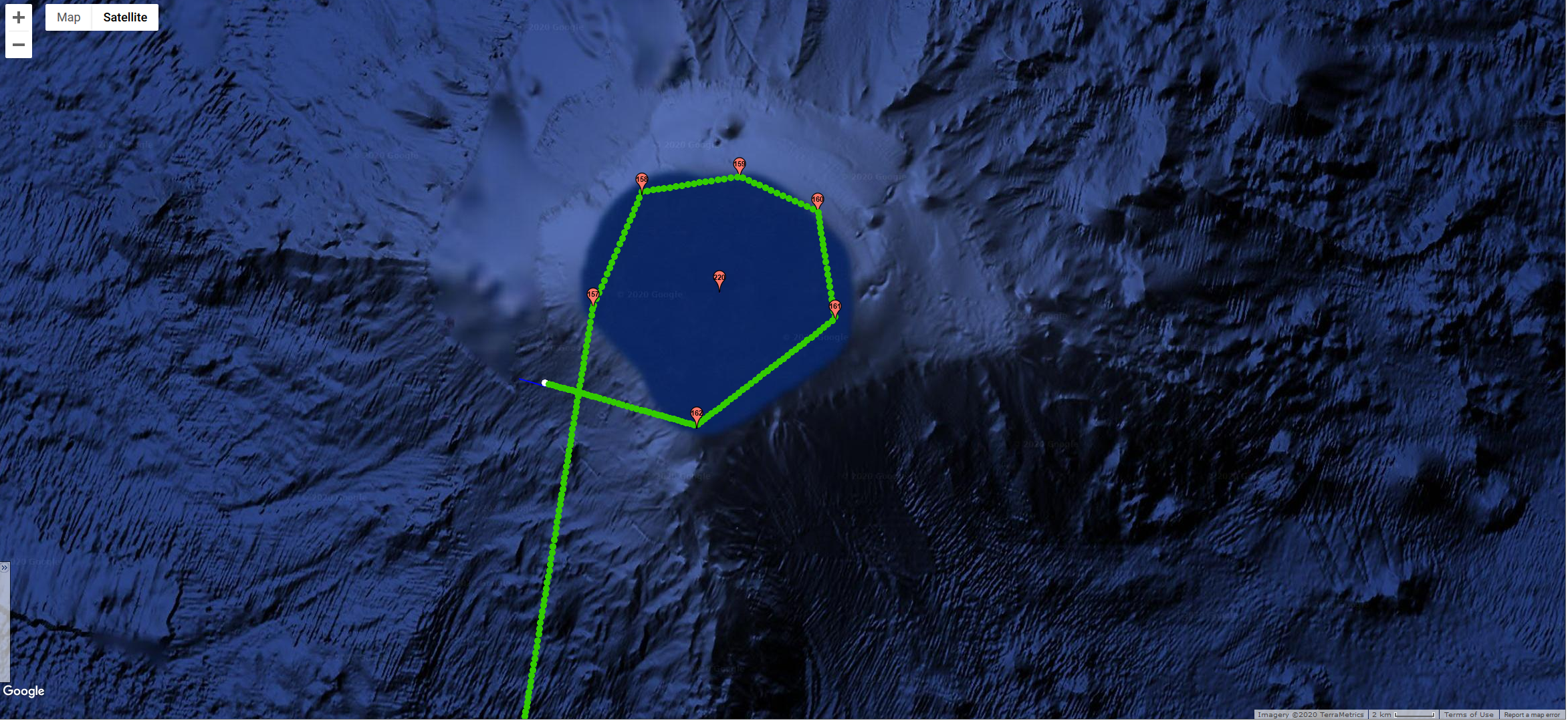
Image of Mokumanamana (aka Necker Island) taken by Google Earth

Image of Mokumanamana (aka Necker Island) taken by Google Earth

Europa has been making good headway the last few days traveling between 1.5- 3 knots in swells up to 11 ft and wind gust up to 13 knots. As she approached and traveled just outside the 200’ contour line on the southwest side of Mokumanamana (map), humpback whale song chorusing increased dramatically.


Mokumanamana (Necker Island) is about 237 miles northwest of Nihoa Island. It is a small basalt island about 1.1 km long and 0.3 km wide and over 10 million years old.

Photo of Mokumanamana by: Kaleomanuiwa Wong, 2010

Photo of Mokumanamana by: Kaleomanuiwa Wong, 2010

The Hawaiian name translates to island (moku) of exponential spiritual power (mana). Mokumanamana is shaped like a fish hook and the emergent land mass is all that remains of a shield volcano that may have once been as large as the island of O‘ahu. In 1786, less than a decade after English explorer Captain James Cook discovered Hawai’i for the Western world, explorer Jean-Francois de La Pérouse visited Mokumanamana and named it Necker Island after Jacques Necker. During the Hawaiian Kingdom era, Mokumanamana was annexed in 1894 by the Provisional Government of Hawai‘i.


Terrestrial animal life on Mokumanamana includes 16 species of nesting seabirds, land snails, wolf spiders, and 15 endemic insects. The island supports five native terrestrial plants, including three Hawaiian islands endemics.


Marine life includes gray reef sharks, manta rays and sixteen species of stony corals. Hawaiian monk seals are seen on the island's rocky shores. A great abundance and diversity of sea cucumbers, sea urchins, and lobsters are found in Shark Bay. Below the shallow reef are extensive deeper "shelves" that extend many miles from the island, especially to the southeast.

Photo of Hawaiian Monk Seal by: Mark Sullivan, NOAA Fisheries, 2007

Photo of Hawaiian Monk Seal by: Mark Sullivan, NOAA Fisheries, 2007

The significance of Mokumanamana goes far beyond the plants and animals that inhabit the island and waters. This island is culturally significant for numerous reasons.

Mokumanamana is situated in an area known as Ke Alanui Polohiwa a Kāne, the great dark glistening sacred path of Kāne god of the sun, which coincides with the Tropic of Cancer. The Tropic of Cancer marks the northernmost extent that the sun travels annually and nowhere north of Mokumanamana can you observe the sun directly overhead. This boundary divides the Hawaiian archipelago into two regions which are Pō and Ao, or basically night and day. In the Hawaiian worldview, Pō is a place of darkness where gods and spirits dwell and Ao is the realm of light and mortality. Most of Papahānaumokuākea resides within Pō, while the inhabited Hawaiian Islands reside within Ao. According to Hawaiian belief, when spirits transition upon death, they travel from Ao in the east to Pō in the west. This is similar to the islands themselves who are volcanically born from the oceanic womb in the east where the sun rises and extends to the west where the sun sets and islands return to their source.

Mokumanamana was understood as a temple from which ancient Hawaiians were able to calibrate time and space through strict religious ceremonies that were performed during significant solar events such as the solstices and equinoxes. Ancestral Hawaiians lined the ridge of Mokumanamana with upright stones (manamana) that align with the path of the sun and other celestial bodies at specific times of the year. Archaeologists surveying Mokumanamana have documented over 52 religious shrines, cultural sites, and artifacts on the island. This is one of the highest concentrations of Native Hawaiian cultural sites in Hawaiʻi. Stone carvings called ki‘i, resembling humans, were found on the island and are unlike any found throughout Hawai‘i or Polynesia. They are part of this larger cultural landscape and the ceremonies associated with the region. Today, Hawaiian cultural researchers are using both Hawaiian and conventional research methods to revitalize these practices through ceremony and science.

Today Europa traces ancient voyaging canoe paths from Ao to Pō, traveling from east to west through Papahānaumokuākea. Still at the beginning of a long voyage, there is much left to explore.


For a look back at Europa's prior journeys, check out our MAP and the Sea Surface Temperature (SST).

Aloha!

Subscribe to our blog

Europa Arrives In The PMNM

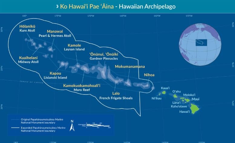
The Papahānaumokuākea Marine National Monument (PMNM) is located in the Northwestern Hawaiian Islands in the central North Pacific roughly 3,000 miles from the nearest continental land mass.

Map of PMNM

Map of PMNM

The PMNM is one of the largest fully protected conservation areas in the world. It encompasses 582,578 square miles (1,508,870 square kilometers) of the Pacific Ocean – an area nearly the size of the Gulf of Mexico!

The Monument, created expressly to protect an exceptional array of natural and cultural resources, was originally established on June 15, 2006 and expanded on August 26, 2016, both times under the authority of the Antiquities Act. It was inscribed as the nation’s first natural and cultural World Heritage Site in 2010.

This isolation has led to the evolution of many unique plants and animals. A significant amount of species within the Monument are endemic to Hawai‘i, found nowhere else on Earth. This area is also rich in ancient cultural sites and historic shipwrecks and landmarks.

Middle Bank is located between the islands of Niʿihau and Nihoa and straddles the boundary of the Monument. It is approximately 5-7 million years old, geologically, and one of several banks in the Monument that was created by volcanic activity and eventually subsided to the ocean. Middle Bank supports deep sea coral communities and bottomfish. The portions of Middle Bank outside of the boundary are occasionally fished for bottomfish.

Jan 21, 2020 - Europa navigating around Middle Bank

Jan 21, 2020 - Europa navigating around Middle Bank

On Jan. 21st, we piloted Europa around the outer edge of Middle Bank along the 200’ depth contour and heard some great humpback whale chorusing. Take a listen below.

20200121T161421_lots_hb_pod_spectrogram.JPG
 
20200121T191421_hb_spectrogram.JPG


For a look back at Europa's prior journeys, check out our MAP and the Sea Surface Temperature (SST).

Aloha!

Subscribe to our blog

Phew…We Made The Crossing!

The Alenuihaha Channel that lies between the Big Island of Hawaii and Maui, is considered one of the most treacherous channels in the world due to the strong winds and high seas that funnel between the two islands’ narrow pass (~26 nm). In the Hawaiian language, alenuihaha means "great billows smashing”, and that it is!! On the day we originally tried to launch Europa, Jan 6th, we were experiencing gale force winds, with gusts over 50mph. We stood by monitoring the weather hourly and were finally able to find a break in the weather on Jan 8th, and successfully launched Europa. However, we were still experiencing gale force winds and seas over 15ft. We decided to not have Europa cross the channel directly from Puako but instead to send Europa 30nm south, off Kailua Kona, in hopes of getting out of the strongest funneling affects. Nonetheless, Europa still faced gusts over 50mph and seas over 15ft. The video below from Windy shows the wind gusts for the channel and Kailua Kona.

Forecast of the extreme sea state that Europa had to travel through at the start of it's journey at the Papahanaumokuakea Marine National Monument. Follow th...

Channel Crossing.JPG
 

Another reason we sent Europa south to cross the channel is that this avoided crossing the densest part of the shipping lanes coming in and out of the state’s ports. Map below shows the vessels and Europa as the yellow star.

Potential Collision.JPG

While she had to dodge several ships, there was one encounter that was quite close. When this happens, we get “Proximity Warning” alarms sent to our cell phones (25 of them in the middle of the night!), notifying us of an oncoming ship. Below is the ship Azamara Journey, that was barrelling down on Europa at 15 knots.

Ship.JPG

Fortunately, Europa has anti-collision software that detects a ship several miles away and when it determines their paths will cross, she takes evasive action to alter her course until the ship has passed by, then gets back on course. At the time of crossing paths, they were 1nm apart (see map below).

Green breadcrumbs are Europa. Grey are Azamara Journey.

Green breadcrumbs are Europa. Grey are Azamara Journey.

 
Europa’s first sunset

Europa’s first sunset

 
Europa taking on waves in the channel

Europa taking on waves in the channel

 
Europa on a stormy day

Europa on a stormy day


For a look back at Europa's prior journeys, check out our MAP and the Sea Surface Temperature (SST).

Aloha!

Subscribe to our blog

HUMPACS PMNM

HUMPACS PMNM

Jupiter Research Foundation (JRF) is pleased to announce that we have been awarded a contract from the U.S. Navy to conduct glider work in the Papahānaumokuākea Marine National Monument (PMNM) (Contract# N39430-19-S-213). This project is a partnership with both the U.S. Navy and the National Oceanic and Atmospheric Administration's (NOAA) Office of National Marine Sanctuaries (ONMS) to better understand underwater sound within the National Marine Sanctuary System. These agencies are working with numerous scientific partners, including JRF, to study the sounds produced by marine animals, physical processes (e.g. wind and waves), and human activities (collectively known as the 'soundscape') within seven national marine sanctuaries and one marine national monument across the U.S.

As part of this national effort, Europa recently embarked on another HUMPACS mission, this time to PMNM where the presence of humpback whales is still poorly documented and understood.  The mission's primary goal is to acoustically document the occurrence of song produced by male humpback whales as a proxy for the relative presence of whales in the Northwestern Hawaiian Islands.

Europa on Jupiter’s RV May Maru with Beth Goodwin, Project Manager of HUMPACS PMNM, and Marc Lammers, PhD, Research Coordinator | Hawaiian Islands Humpback Whale National Marine Sanctuary

Europa on Jupiter’s RV May Maru with Beth Goodwin, Project Manager of HUMPACS PMNM, and Marc Lammers, PhD, Research Coordinator | Hawaiian Islands Humpback Whale National Marine Sanctuary

Europa launched and ready for her voyage

Europa launched and ready for her voyage

It was a blustery day with a beautiful rainbow on the horizon

It was a blustery day with a beautiful rainbow on the horizon


For a look back at Europa's prior journeys, check out our MAP and the Sea Surface Temperature (SST).

Aloha!

Subscribe to our blog

End of year...

Our HUMPACS project has made for an exciting and busy year. To wrap it up, Beth had the opportunity to present the results of our HUMPACS East mission at the World Marine Mammal Conference in Barcelona, Spain Dec 6-12, 2019. She presented in the session on “Assessing Marine Mammals in the High Seas” as well as in the workshop “Using smart acoustic technology to detect, classify, localize and track marine species”.

Beth presenting at the WMMC

Beth presenting at the WMMC

Beth Goodwin, Rose Fisher, Jillian Duggan, Ashley Noseworthy (left to right)

Beth Goodwin, Rose Fisher, Jillian Duggan, Ashley Noseworthy (left to right)

We have another HUMPACS mission planned for 2020! Check back in with us in January, in the mean time wishing you all a Joyful Holiday and a Happy New Year!!


For a look back at Europa's prior journeys, check out our MAP and the Sea Surface Temperature (SST).

Aloha!

Subscribe to our blog

For Immediate Release:

Ed Lyman-HIHWNMS-NOAA Fisheries Permit #782-1719 (Original image has been altered to include Wave Glider) - Copy1.png


Autonomous (Robotic) Wave Glider Mission from Hawaii to Mexico Detects Humpback Whale Calls in Tropical Mid-Ocean and Questions Definition of Winter Breeding Assemblies 

Current NMFS humpback whale management policies assume Mexico and Hawaii winter assemblies are distinct with separate status and management warranted


BIG ISLAND, HAWAII July 1, 2019 – Jupiter Research Foundation and Whale Trust are pleased to announce the publication of the results of the first leg of their autonomous Wave Glider HUMPACS (Humpback Pacific Survey) acoustic survey in Journal of the Acoustic Society of America – Express Letters. During a 100-day nearly 7,000 km (3,800 nm) round trip survey on a line between Hawaii and Mexico within the 2018 winter breeding season, humpback whale calls were heard in mid-ocean basin, halfway between the known near-shore assemblies. 

“They’re not ‘supposed’ to be there,” says Dr. Jim Darling, Whale Trust biologist and project partner. Humpbacks are known to assemble in specific near-shore, relatively shallow, breeding grounds in Mexico and Hawaii. “But then no one has looked in these more remote, offshore areas either.”

Mission control was from Puako, Hawaii where Beth Goodwin, Jupiter Research Foundation VP and HUMPACS Project Manager, and her team were in daily communication with the Wave Glider: monitoring status, downloading surface and underwater photographs, downloading short samples of recordings via satellite, and making course alterations if needed. 

From January 16 to April 25, 2018, the Wave Glider, named Europa (after one of Jupiter’s moons), performed a 6,965.5 km, 100-day (RT) continual acoustic survey from Hawaii towards Mexico circa 20° N. The survey resulted in 2,272 hours of recordings and included over 4,000 cetacean calls.  Of these calls, 2,048 were identified as humpback whale calls.

The humpback calls were recorded up to 2,184 km (1179 nm) offshore spanning 30 days between January 20, when the Wave Glider left Hawaii, to February 23, 2018. On many days, multiple humpback call detections were recorded (up to 377 calls over 23 hours of a day). Actual numbers of whales cannot be determined, as one whale can make many calls.

“This was risky, we had no idea if humpbacks were even out there,” says Goodwin. “And then, even if they were, there were needle-in-haystack odds of intersecting them considering the size of the Wave Glider and the size of the ocean.”

Possible explanations, suggests Darling, include an undocumented migration route to Hawaii, a separate (from Hawaii and Mexico) offshore assembly of humpback whales, or travel between Mexico and Hawaii assemblies within the same season. At the very least, these results indicate an extension of winter distribution and habitat of humpbacks. It could also be that these offshore whales have not been included in current population estimates.

Since 2016, the model used by the U.S. National Marine Fisheries Service (NMFS) to manage humpback whale populations has treated the Mexico and Hawaii winter assemblies of humpback whales as distinct populations. As such, these populations have different status under the U.S. Endangered Species Act (ESA): Mexico humpback whales are considered threatened while Hawaii humpback whales have been delisted; that is, the Hawaii population has no protection under the ESA.

This assessment is further complicated by longstanding research showing shared song between the breeding assemblies and an interchange of photo-identified individual whales between these two winter breeding grounds.

Our findings question the independence of Mexico and Hawaii humpback whale populations and illustrate the huge potential for the use of autonomous vehicles in the study of whales across remote locations of the ocean.

“We feel certain our results will encourage more research, affect how humpback and other whales are monitored, and help with management,” says Goodwin.

The paper is online: https://doi.org/10.1121/1.5111970


BACKGROUND


Wave Glider

The Wave Glider (produced by Liquid Robotics, a Boeing Company) consists of a surfboard-sized surface platform (the float) tethered by an umbilical cable to a submerged glider (the sub) 8 m (26 ft.) below the surface. The float includes a command and control unit, three solar panels, an instrument package, surface and underwater cameras and communications systems. The sub is the propulsion unit, which transforms vertical wave movement into forward motion (https://www.liquid-robotics.com/wave-glider/how-it-works/). Time-lapse series of images from the two Europa cameras, surface and underwater, are accessible on the JRF blog:
http://jupiterfoundation.org/current/2018/5/22/f2l6bevguh177l21x42gi20pegicbv

About Jupiter Research Foundation

The Jupiter Research Foundation is a 501(c)(3) non-profit scientific research organization. Established in 2003, the Foundation is dedicated to conducting innovative scientific research and finding technological solutions to problems which are outside of mainstream science and technology. Our findings are shared with the public and academic community in hopes of better monitoring and understanding the natural world. Visit https://jupiterfoundation.org/ to learn more. 

About Whale Trust

Whale Trust is a Maui-based 501(c)(3) non-profit organization whose mission is to promote, support and conduct scientific research on whales and the marine environment and broadly communicate the findings to the public. Whale Trust research programs focus on behavior, communication and social organization of whales. For more information, visit https://whaletrust.org/.


For a look back at Europa's prior journeys, check out our MAP and the Sea Surface Temperature (SST).

Aloha!

Subscribe to our blog

HUMPACS East Results Are In!

We know you’ve all been waiting to hear about the success of HUMPACS East, and believe us, we’ve been just as anxious to let you all know.

Our results have just been published in the The Journal of the Acoustical Society of Amer (Vol.145, No.6).

The purpose of this study was to investigate if whales were present in the offshore waters between the Hawaii and Mexico breeding grounds where, to our knowledge, they have never been documented before. It’s a big ocean out there, so we were searching for a needle in a haystack…and we were successful!

Publication East Map.jpg

We identified humpback calls out to 1,200nm from Hawaii, approximately midway to Mexico.

Our findings raise more questions regarding humpback whale breeding grounds, migration routes, and habitat. We have presented our results to the Marine Mammal Commission and hope to present at the World Marine Mammal Science Conference in Barcelona, December, 2019. We feel certain our results will elicit more research, affect how marine mammals are monitored and help with management.

Read the Publication (link to PDF)

Supplemental Material (link to download)

Copyright 2019 Acoustical Society of America. This article may be downloaded for personal use only. Any other use requires prior permission of the author and the Acoustical Society of America. The article appeared in The Journal of the Acoustical Society of Amer (Vol.145, No.6) and may be found at https://doi.org/10.1121/1.5111970.

Below is a short annotated power point presentation of our mission and results.

Aloha!


For a look back at Europa's prior journeys, check out our MAP and the Sea Surface Temperature (SST).

Aloha!

Subscribe to our blog

Europa's Journey and Recovery

We know you’ve all been waiting anxiously to see the photos from Europa from the last few months, as well as the journey from Majuro, Marshall Islands, 650nm north to recovery her out in the middle of the Pacific. This could not have been done without the Indies Surveyor!

Well, the wait is over!

We’d like to make sure and thank EVERYONE that was involved in the recovery effort. There are so many people that lent a hand when we needed it, and we truly appreciate it.

Enjoy,


For a look back at Europa's prior journeys, check out our MAP and the Sea Surface Temperature (SST).

Aloha!

Subscribe to our blog

Back to Hawaii

After 14 days of travel and adventure, we’re happy to say that Beth and Murray have touched ground back on the Big Island!

They successfully recovered Europa and all of the valuable scientific data that was collected on the mission. They then cleaned, disassembled, and packed up Europa in her entirety and shipped her home. She is expected to arrive on the Big Island within the next day or two.

For now, we are beginning to analyze the acoustic data. This is a pretty long and tedious task, but extremely valuable and necessary.

We have lots of video and pictures documenting the trip, and will post some of them in later updates.

Until then, check it out…we made the Marshall Islands newspaper!

Aloha!


For a look back at Europa's prior journeys, check out our MAP and the Sea Surface Temperature (SST).

Aloha!

Subscribe to our blog