PMNM

Hawaiian Archipelago

Aloha everyone,

As 2020 comes to an end, we wanted to present the preliminary report by Dr. Marc Lammers of our Wave Glider Mission through the PMNM.

Have a safe and joyous holiday!

“November 6, 2020

Dr. Marc Lammers, Research Coordinator at NOAA's Hawaiian Islands Humpback Whale National Marine Sanctuary

This presentation describes recent fluctuations in the presence of humpback whales in Hawaiʻi over the past several years and the science being conducted to understand these trends. Dr. Marc Lammers discusses the application of novel tools to understand the occurrence of humpback whales in remote habitats, including the use of a Wave Glider and machine learning algorithms to detect the presence of whales in the Papahānaumokuākea Marine National Monument.

This presentation is part of the Kauai Ocean Discovery speaker series that is celebrating November, which is Ho`i Koholā (Return of Humpback Whale Month).”

Reference:

https://sanctuaries.noaa.gov/education/teachers/occurrence-humpback-whales-through-acoustics.html


For a look back at Europa's prior journeys, check out our MAP and the Sea Surface Temperature (SST).

Aloha!

Subscribe to our blog

Europa's Voyage

Below are two time lapse videos of Europa’s Voyage through The Papahānaumokuākea Marine National Monument. We had two cameras taking pictures from sunrise to sunset approximately every 1.5 to 3 hours.

The first video is from a camera mounted on the back end of the float. At the beginning of the journey you’ll see some ti leaves on the float. This was part of Europa’s blessing before embarking on her voyage through the PMNM. As you can see, Europa experienced some rough seas, beautiful sunrises and sunsets, full moons, and calm days with an occasional booby resting on the warm solar panels.

The second video is from a camera mounted in the float looking down at the sub and umbilical. You’ll note that the sub moves around quite a bit. There were times when the umbilical had slack and the wings were fully rotated up or down, indicating rough seas. Occasionally, fish even gathered around the sub.

Please enjoy the videos.


For a look back at Europa's prior journeys, check out our MAP and the Sea Surface Temperature (SST).

Aloha!

Subscribe to our blog

Land Ho, Land Ho!

Europa has finally made it home and was safely recovered March 14th. This type of survey throughout the pristine Papahānaumokuākea Marine National Monument has been the first of its kind. We are very proud of the mission and collaboration with the Navy and NOAA Sanctuary. Thank you all for following Europa’s journey.

 
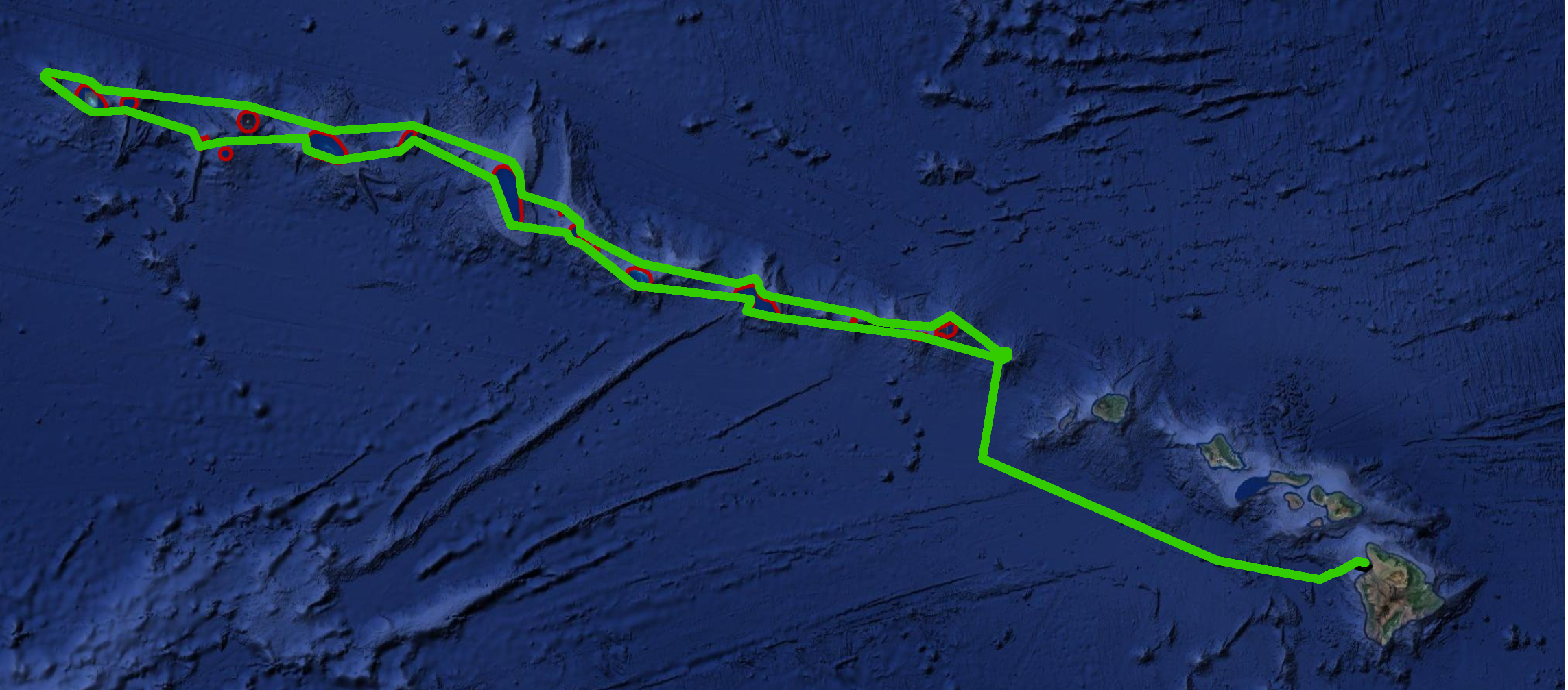
Europa’s course navigating outside of the 200’ depth contour (red circles) throughout the PMNM

Europa’s course navigating outside of the 200’ depth contour (red circles) throughout the PMNM

 
Europa lays eyes on the Kohala Coast and Mauna Kea on the Big Island

Europa lays eyes on the Kohala Coast and Mauna Kea on the Big Island

Europa with view of Mauna Kea: Land Ho!

Europa with view of Mauna Kea: Land Ho!

 
View of Europa from the May Maru

View of Europa from the May Maru

Europa, moments before recovery on the May Maru

Europa, moments before recovery on the May Maru

 
Given the current Covid-19 pandemic, Europa follows appropriate bio-security protocol

Given the current Covid-19 pandemic, Europa follows appropriate bio-security protocol

She's not sure about coming to shore after her journey in the pristine, uninhabited, PMNM. Please stay safe!

She's not sure about coming to shore after her journey in the pristine, uninhabited, PMNM. Please stay safe!

 
Recovery crew: Beth, Maya, and Jessica (from left to right)

Recovery crew: Beth, Maya, and Jessica (from left to right)


For a look back at Europa's prior journeys, check out our MAP and the Sea Surface Temperature (SST).

Aloha!

Subscribe to our blog

Homeward Bound

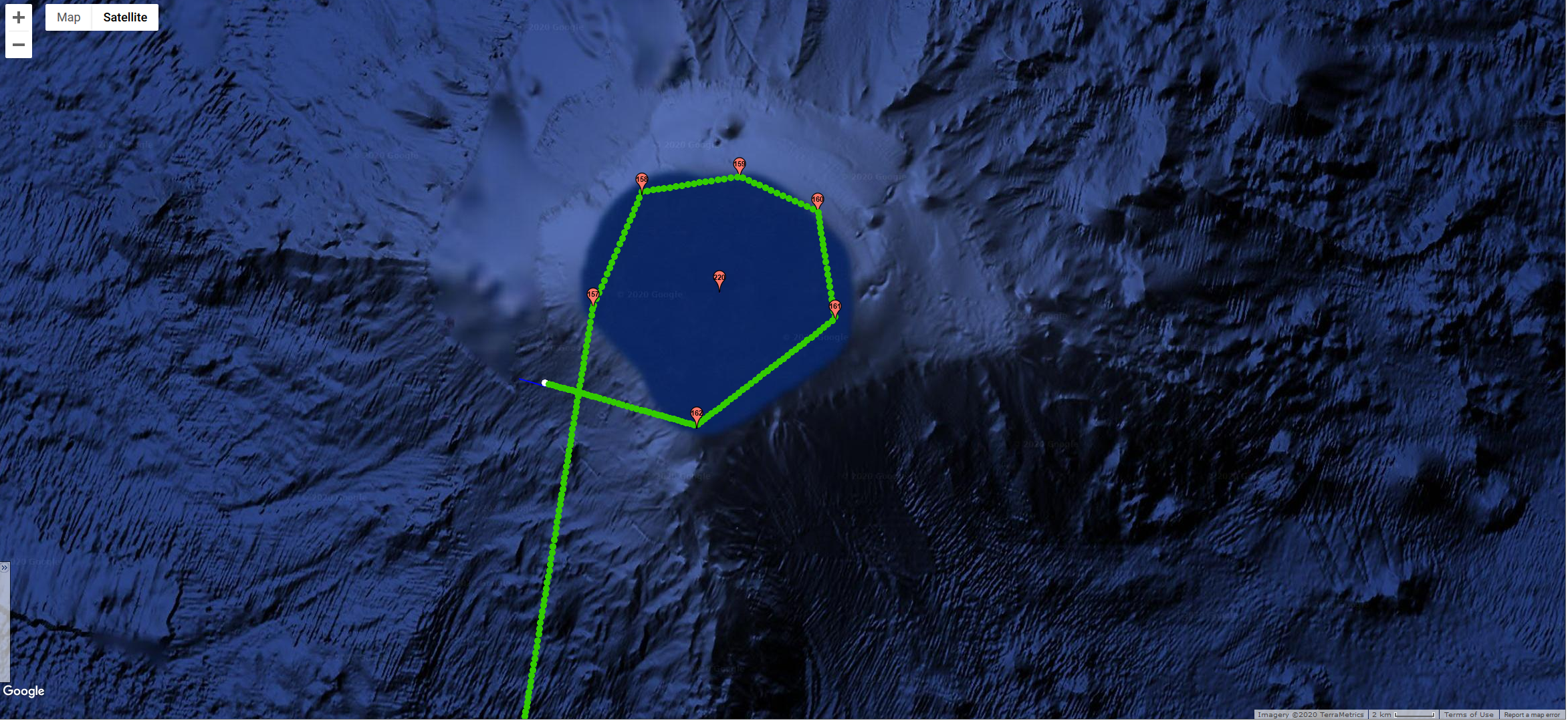
Europa is on her way home after successfully surveying The Papahānaumokuākea National Marine Monument. As she exited the monument, she concluded with a cross through, and circle around, Middle Bank.

We expect to recover her in Puako sometime in the next 5-7 days, but the journey is not over yet. For this last leg, Europa has been faced with strong winds and high seas, as well as had to dodge a number of cargo and passenger vessels.

Today, a passenger vessel from the Bahamas, headed to Oahu, passed behind her. The vessel’s name was Europa, a good omen we hope!

The entire team from Jupiter, NOAA and the Navy anxiously await her recovery.

Stay tuned!

Europa passing through, and then circling, Middle Bank at the end of her PMNM journey.

Europa passing through, and then circling, Middle Bank at the end of her PMNM journey.

 
A look at all of the marine traffic that Europa is avoiding on her way back home to Puako. Each of those yellow and red dots represent a cluster of vessel breadcrumbs.

A look at all of the marine traffic that Europa is avoiding on her way back home to Puako. Each of those yellow and red dots represent a cluster of vessel breadcrumbs.

 
Europa vessel that passed by our wave glider Europa earlier today.

Europa vessel that passed by our wave glider Europa earlier today.

 
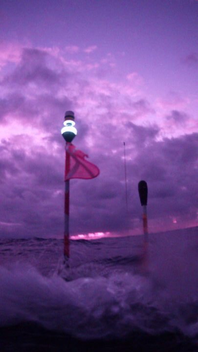
Sunrise from Europa in some heavy seas.

Sunrise from Europa in some heavy seas.

Moonrise (supermoon) from Europa with waves crashing.

Moonrise (supermoon) from Europa with waves crashing.


For a look back at Europa's prior journeys, check out our MAP and the Sea Surface Temperature (SST).

Aloha!

Subscribe to our blog

Half Way Mark - Lisianski and Neva Shoals

We are happy to report that we have continued to hear humpback whales and other species as we passed the North Hampton Seamounts and Neva Shoals at the very north end of our voyage. Of note, the Sea Surface Temperatures (SST) continued to drop. Last night we rounded the north end of Lisianski Island and are now officially headed back down the other side of the chain making our way back home. Below are some pictures from Europa, as well as a couple of audio files from her voyage to the north end of the chain.

A booby catching a ride on Europa

A booby catching a ride on Europa

A beautiful sunset seen from Europa

A beautiful sunset seen from Europa

 
20200207T064000_hb_mn_od_clicking_either_FalseKillerW_PilotWhale.JPG
 
20200208T153958_VeryGood_lots_hb_Good_mk.JPG

Located 208 kilometers (129 miles) northwest from Laysan is the island commonly known as Lisianski. Another name for Lisianski is Papa‘āpoho. It is a combination of two words. Papa means a reef, flat surface, or foundation and ‘āpoho means depression, hollow, or pitted. Combined, they describe the depression between two tall sand dunes which may have once been the location of a lake similar to the one on Laysan.

About 20 million years ago, geologic forces raised the tip of a huge coral bank above sea level. Today, Lisianski Island is 1.5 square kilometers (381 acres), about the size of Honolulu. While its land mass is relatively small, Lisianski’s coral reef, known as Neva Shoals, is massive at 310,000 acres or 1,254.5 square kilometers, an area nearly the size of O‘ahu.

The first western explorer to reach the island was the Russian Captain Yuri Feodorovich Lisyansky in 1805. The captain ran aground in his ship, the Neva, after which the shoal to the south was named. Various ships visited Lisianski throughout the 1800s to harvest fish, turtles, guano, beche-de-mer (sea cucumbers), sharks, and seals. During this period rats and mice arrived on Lisianski in the 1800s as accidental introductions, and rabbits were purposely introduced by humans as a food source. These mammals consumed most of the vegetation and negatively impacted the terrestrial ecology. Captain John Paty claimed the island for the Kingdom of Hawai‘i on behalf of Kamehameha IV on May 10, 1857. In 1890, the North Pacific Phosphate and Fertilizer Company acquired a twenty-year lease to mine the island for guano. From 1904 to 1909 Japanese feather poachers harvested birds from the island. This activity was stopped after Lisianski became part of the Hawaiian Islands Bird Reservation in 1909.

Today, Hawaiian monk seals and green sea turtles are common visitors to Lisianski's sandy white beaches. Migratory shorebirds seen on the island include the kolea (golden plover), ulili (wandering tattler), and kioea (bristle-thighed curlew). Nearly three-fourths of the Bonin petrels nesting in Hawai’i make this island their home. In some years, more than a million sooty terns visit Lisianski.

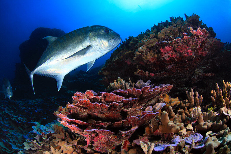
Photo by: Greg McFall/NOAA Office of National Marine Sanctuaries, 2011Coral and giant trevally / ulua aukea (Caranx ignobilis) at Lisianski Island in Papahānaumokuākea Marine National Monument.

Photo by: Greg McFall/NOAA Office of National Marine Sanctuaries, 2011

Coral and giant trevally / ulua aukea (Caranx ignobilis) at Lisianski Island in Papahānaumokuākea Marine National Monument.

Reef fishes of the nearshore waters are abundant and diverse. Researchers have found predators near Lisianski's reefs, such as sharks, to be very aggressive. Even ulua (Trevally jacks) will harass divers and small boats. The reefs of Lisianski and surrounding Neva Shoals are called "coral gardens" by some scientists because of their abundance of coral and the variety of growth forms assumed by their colonies, including structures resembling spires, castles, and a variety of other shapes.


For a look back at Europa's prior journeys, check out our MAP and the Sea Surface Temperature (SST).

Aloha!

Subscribe to our blog

Welcome to Mokumanamana

Image of Mokumanamana (aka Necker Island) taken by Google Earth

Image of Mokumanamana (aka Necker Island) taken by Google Earth

Europa has been making good headway the last few days traveling between 1.5- 3 knots in swells up to 11 ft and wind gust up to 13 knots. As she approached and traveled just outside the 200’ contour line on the southwest side of Mokumanamana (map), humpback whale song chorusing increased dramatically.


Mokumanamana (Necker Island) is about 237 miles northwest of Nihoa Island. It is a small basalt island about 1.1 km long and 0.3 km wide and over 10 million years old.

Photo of Mokumanamana by: Kaleomanuiwa Wong, 2010

Photo of Mokumanamana by: Kaleomanuiwa Wong, 2010

The Hawaiian name translates to island (moku) of exponential spiritual power (mana). Mokumanamana is shaped like a fish hook and the emergent land mass is all that remains of a shield volcano that may have once been as large as the island of O‘ahu. In 1786, less than a decade after English explorer Captain James Cook discovered Hawai’i for the Western world, explorer Jean-Francois de La Pérouse visited Mokumanamana and named it Necker Island after Jacques Necker. During the Hawaiian Kingdom era, Mokumanamana was annexed in 1894 by the Provisional Government of Hawai‘i.


Terrestrial animal life on Mokumanamana includes 16 species of nesting seabirds, land snails, wolf spiders, and 15 endemic insects. The island supports five native terrestrial plants, including three Hawaiian islands endemics.


Marine life includes gray reef sharks, manta rays and sixteen species of stony corals. Hawaiian monk seals are seen on the island's rocky shores. A great abundance and diversity of sea cucumbers, sea urchins, and lobsters are found in Shark Bay. Below the shallow reef are extensive deeper "shelves" that extend many miles from the island, especially to the southeast.

Photo of Hawaiian Monk Seal by: Mark Sullivan, NOAA Fisheries, 2007

Photo of Hawaiian Monk Seal by: Mark Sullivan, NOAA Fisheries, 2007

The significance of Mokumanamana goes far beyond the plants and animals that inhabit the island and waters. This island is culturally significant for numerous reasons.

Mokumanamana is situated in an area known as Ke Alanui Polohiwa a Kāne, the great dark glistening sacred path of Kāne god of the sun, which coincides with the Tropic of Cancer. The Tropic of Cancer marks the northernmost extent that the sun travels annually and nowhere north of Mokumanamana can you observe the sun directly overhead. This boundary divides the Hawaiian archipelago into two regions which are Pō and Ao, or basically night and day. In the Hawaiian worldview, Pō is a place of darkness where gods and spirits dwell and Ao is the realm of light and mortality. Most of Papahānaumokuākea resides within Pō, while the inhabited Hawaiian Islands reside within Ao. According to Hawaiian belief, when spirits transition upon death, they travel from Ao in the east to Pō in the west. This is similar to the islands themselves who are volcanically born from the oceanic womb in the east where the sun rises and extends to the west where the sun sets and islands return to their source.

Mokumanamana was understood as a temple from which ancient Hawaiians were able to calibrate time and space through strict religious ceremonies that were performed during significant solar events such as the solstices and equinoxes. Ancestral Hawaiians lined the ridge of Mokumanamana with upright stones (manamana) that align with the path of the sun and other celestial bodies at specific times of the year. Archaeologists surveying Mokumanamana have documented over 52 religious shrines, cultural sites, and artifacts on the island. This is one of the highest concentrations of Native Hawaiian cultural sites in Hawaiʻi. Stone carvings called ki‘i, resembling humans, were found on the island and are unlike any found throughout Hawai‘i or Polynesia. They are part of this larger cultural landscape and the ceremonies associated with the region. Today, Hawaiian cultural researchers are using both Hawaiian and conventional research methods to revitalize these practices through ceremony and science.

Today Europa traces ancient voyaging canoe paths from Ao to Pō, traveling from east to west through Papahānaumokuākea. Still at the beginning of a long voyage, there is much left to explore.


For a look back at Europa's prior journeys, check out our MAP and the Sea Surface Temperature (SST).

Aloha!

Subscribe to our blog

Europa Arrives In The PMNM

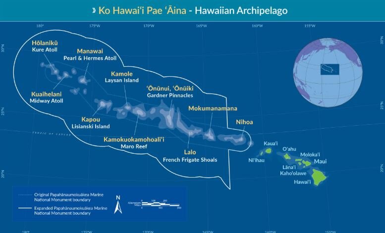
The Papahānaumokuākea Marine National Monument (PMNM) is located in the Northwestern Hawaiian Islands in the central North Pacific roughly 3,000 miles from the nearest continental land mass.

Map of PMNM

Map of PMNM

The PMNM is one of the largest fully protected conservation areas in the world. It encompasses 582,578 square miles (1,508,870 square kilometers) of the Pacific Ocean – an area nearly the size of the Gulf of Mexico!

The Monument, created expressly to protect an exceptional array of natural and cultural resources, was originally established on June 15, 2006 and expanded on August 26, 2016, both times under the authority of the Antiquities Act. It was inscribed as the nation’s first natural and cultural World Heritage Site in 2010.

This isolation has led to the evolution of many unique plants and animals. A significant amount of species within the Monument are endemic to Hawai‘i, found nowhere else on Earth. This area is also rich in ancient cultural sites and historic shipwrecks and landmarks.

Middle Bank is located between the islands of Niʿihau and Nihoa and straddles the boundary of the Monument. It is approximately 5-7 million years old, geologically, and one of several banks in the Monument that was created by volcanic activity and eventually subsided to the ocean. Middle Bank supports deep sea coral communities and bottomfish. The portions of Middle Bank outside of the boundary are occasionally fished for bottomfish.

Jan 21, 2020 - Europa navigating around Middle Bank

Jan 21, 2020 - Europa navigating around Middle Bank

On Jan. 21st, we piloted Europa around the outer edge of Middle Bank along the 200’ depth contour and heard some great humpback whale chorusing. Take a listen below.

20200121T161421_lots_hb_pod_spectrogram.JPG
 
20200121T191421_hb_spectrogram.JPG


For a look back at Europa's prior journeys, check out our MAP and the Sea Surface Temperature (SST).

Aloha!

Subscribe to our blog