HUMPACS PMNM

Europa Arrives In The PMNM

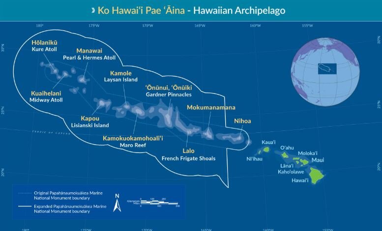
The Papahānaumokuākea Marine National Monument (PMNM) is located in the Northwestern Hawaiian Islands in the central North Pacific roughly 3,000 miles from the nearest continental land mass.

Map of PMNM

Map of PMNM

The PMNM is one of the largest fully protected conservation areas in the world. It encompasses 582,578 square miles (1,508,870 square kilometers) of the Pacific Ocean – an area nearly the size of the Gulf of Mexico!

The Monument, created expressly to protect an exceptional array of natural and cultural resources, was originally established on June 15, 2006 and expanded on August 26, 2016, both times under the authority of the Antiquities Act. It was inscribed as the nation’s first natural and cultural World Heritage Site in 2010.

This isolation has led to the evolution of many unique plants and animals. A significant amount of species within the Monument are endemic to Hawai‘i, found nowhere else on Earth. This area is also rich in ancient cultural sites and historic shipwrecks and landmarks.

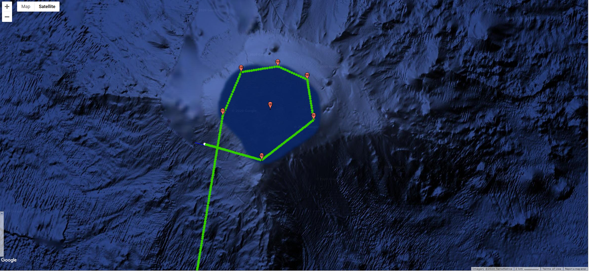
Middle Bank is located between the islands of Niʿihau and Nihoa and straddles the boundary of the Monument. It is approximately 5-7 million years old, geologically, and one of several banks in the Monument that was created by volcanic activity and eventually subsided to the ocean. Middle Bank supports deep sea coral communities and bottomfish. The portions of Middle Bank outside of the boundary are occasionally fished for bottomfish.

Jan 21, 2020 - Europa navigating around Middle Bank

Jan 21, 2020 - Europa navigating around Middle Bank

On Jan. 21st, we piloted Europa around the outer edge of Middle Bank along the 200’ depth contour and heard some great humpback whale chorusing. Take a listen below.

20200121T161421_lots_hb_pod_spectrogram.JPG
 
20200121T191421_hb_spectrogram.JPG


For a look back at Europa's prior journeys, check out our MAP and the Sea Surface Temperature (SST).

Aloha!

Subscribe to our blog

Phew…We Made The Crossing!

The Alenuihaha Channel that lies between the Big Island of Hawaii and Maui, is considered one of the most treacherous channels in the world due to the strong winds and high seas that funnel between the two islands’ narrow pass (~26 nm). In the Hawaiian language, alenuihaha means "great billows smashing”, and that it is!! On the day we originally tried to launch Europa, Jan 6th, we were experiencing gale force winds, with gusts over 50mph. We stood by monitoring the weather hourly and were finally able to find a break in the weather on Jan 8th, and successfully launched Europa. However, we were still experiencing gale force winds and seas over 15ft. We decided to not have Europa cross the channel directly from Puako but instead to send Europa 30nm south, off Kailua Kona, in hopes of getting out of the strongest funneling affects. Nonetheless, Europa still faced gusts over 50mph and seas over 15ft. The video below from Windy shows the wind gusts for the channel and Kailua Kona.

Forecast of the extreme sea state that Europa had to travel through at the start of it's journey at the Papahanaumokuakea Marine National Monument. Follow th...

Channel Crossing.JPG
 

Another reason we sent Europa south to cross the channel is that this avoided crossing the densest part of the shipping lanes coming in and out of the state’s ports. Map below shows the vessels and Europa as the yellow star.

Potential Collision.JPG

While she had to dodge several ships, there was one encounter that was quite close. When this happens, we get “Proximity Warning” alarms sent to our cell phones (25 of them in the middle of the night!), notifying us of an oncoming ship. Below is the ship Azamara Journey, that was barrelling down on Europa at 15 knots.

Ship.JPG

Fortunately, Europa has anti-collision software that detects a ship several miles away and when it determines their paths will cross, she takes evasive action to alter her course until the ship has passed by, then gets back on course. At the time of crossing paths, they were 1nm apart (see map below).

Green breadcrumbs are Europa. Grey are Azamara Journey.

Green breadcrumbs are Europa. Grey are Azamara Journey.

 
Europa’s first sunset

Europa’s first sunset

 
Europa taking on waves in the channel

Europa taking on waves in the channel

 
Europa on a stormy day

Europa on a stormy day


For a look back at Europa's prior journeys, check out our MAP and the Sea Surface Temperature (SST).

Aloha!

Subscribe to our blog

HUMPACS PMNM

HUMPACS PMNM

Jupiter Research Foundation (JRF) is pleased to announce that we have been awarded a contract from the U.S. Navy to conduct glider work in the Papahānaumokuākea Marine National Monument (PMNM) (Contract# N39430-19-S-213). This project is a partnership with both the U.S. Navy and the National Oceanic and Atmospheric Administration's (NOAA) Office of National Marine Sanctuaries (ONMS) to better understand underwater sound within the National Marine Sanctuary System. These agencies are working with numerous scientific partners, including JRF, to study the sounds produced by marine animals, physical processes (e.g. wind and waves), and human activities (collectively known as the 'soundscape') within seven national marine sanctuaries and one marine national monument across the U.S.

As part of this national effort, Europa recently embarked on another HUMPACS mission, this time to PMNM where the presence of humpback whales is still poorly documented and understood.  The mission's primary goal is to acoustically document the occurrence of song produced by male humpback whales as a proxy for the relative presence of whales in the Northwestern Hawaiian Islands.

Europa on Jupiter’s RV May Maru with Beth Goodwin, Project Manager of HUMPACS PMNM, and Marc Lammers, PhD, Research Coordinator | Hawaiian Islands Humpback Whale National Marine Sanctuary

Europa on Jupiter’s RV May Maru with Beth Goodwin, Project Manager of HUMPACS PMNM, and Marc Lammers, PhD, Research Coordinator | Hawaiian Islands Humpback Whale National Marine Sanctuary

Europa launched and ready for her voyage

Europa launched and ready for her voyage

It was a blustery day with a beautiful rainbow on the horizon

It was a blustery day with a beautiful rainbow on the horizon


For a look back at Europa's prior journeys, check out our MAP and the Sea Surface Temperature (SST).

Aloha!

Subscribe to our blog