How the Sea Shapes our Lives

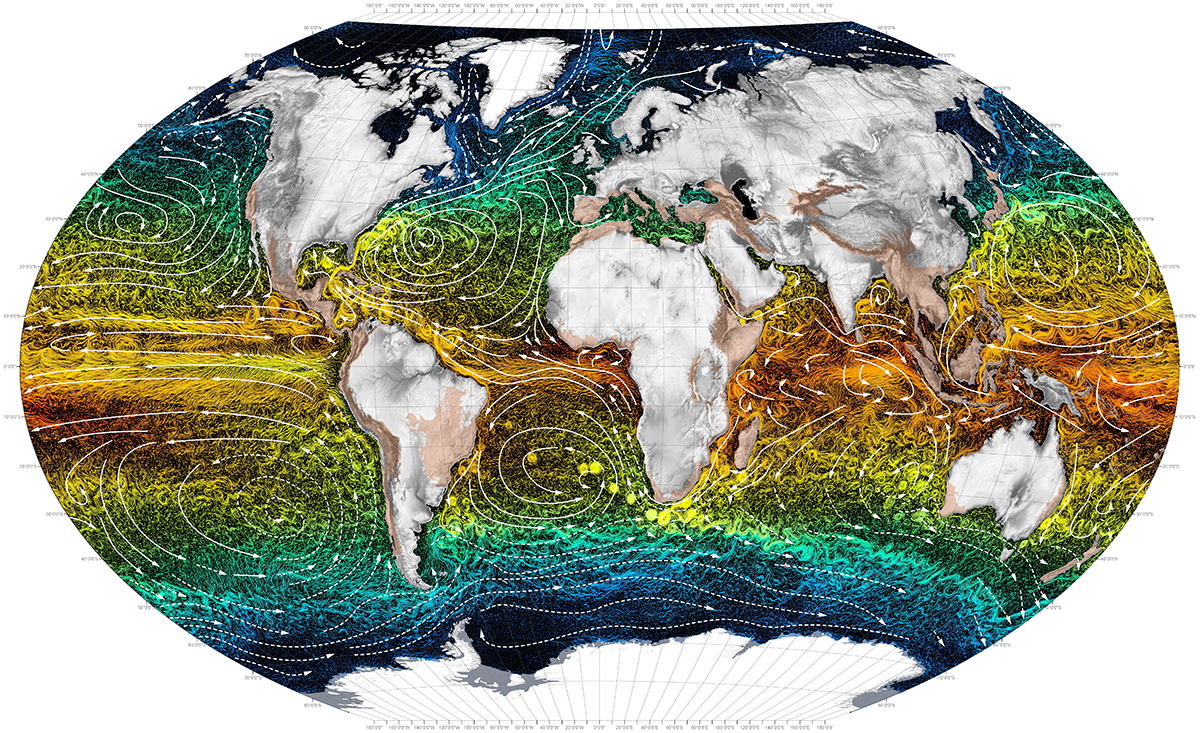
Ocean Currents. Photo by Atlas for the End of the World

Ocean Currents. Photo by Atlas for the End of the World

The vast, mysterious ocean, covering 71 percent of the Earth, plays an essential role in our everyday lives. Not just for the coastal and island dwellers, but for everyone. The ocean provides many ecosystem services, including food production, fisheries, pharmaceuticals, oxygen regulation, carbon storage and sequestering, water quality enhancement, coastal protection, biodiversity, economy, cultural values, and climate and weather regulation. Without the ocean, we would not be able to survive.

One of the most critical ecosystem services of the ocean is weather and climate regulation because it affects economies and livelihoods on a global scale. The sea has a low albedo, meaning it absorbs most of the sun’s heat radiation. Thus, water molecules heat up and evaporate into the atmosphere and create storms that are carried over long distances by trade winds and currents. These storms can become destructive as they accumulate warm water while traveling over the ocean.

Ocean currents are crucial for regulating the climate and transferring heat around the globe. Water density, winds, tides, and the earth’s rotation direct and power the currents, which are found on the ocean’s surface and at a depth below 900 feet. They move water horizontally and vertically and occur on a local and global scale. The currents create a global conveyor belt that acts as a global circulation system. It transfers warm water and precipitation from the equator towards the cold-watered poles and vice versa. It also plays a vital role in distributing nutrients across the ocean.

As seasons change, so do wind and weather trends, sea surface temperatures, and currents. Currents are stronger in the winter than they are in the summer because there are stronger winds and colder sea temperatures. Furthermore, spring is a considerable transition period. During this time, temperatures begin to warm, the density and salinity of the ocean changes, and wind patterns shift. These factors significantly influence currents, causing them to become unstable.

Without currents, the land wouldn’t be habitable because temperatures would be too extreme; the equator too hot and the poles too cold. Additionally, the precipitation distributed by currents and wind is necessary to all living things and is needed to sustain life. Foreseeable current, weather, and climate trends are key components in maintaining a healthy economy by supporting crops, livestock, tourism, etc., and can also save lives from dangerous storms and create more resilient communities.

Currents are measured and monitored by moored and drifting buoys that relay data via satellite. These buoys are efficient in collecting data, but they are quite costly and require much effort to deploy, retrieve, and maintain. Moored buoys often break from their mooring and can't be implemented in deep waters. Wave Gliders, however, can measure and monitor surface currents on a local and global scale in any seas without the considerable exertion and cost. Therefore, they could be utilized as an alternative to some of the moored buoys or drifters while collecting other vital data such as salinity, sea surface temp, CO2 levels, and much more. 

Europa has not experienced much trouble from the changing spring currents thus far. Although, on April 5th, she hit a robust northern current with no sea state to give her power, which made her veer off course a little. Fortunately, we were able to turn on the thruster (a small solar powered, electric propeller on the sub) that quickly put her back on track. We hope the currents remain steady and in our favor, so she’ll return home as soon as possible.


For a look back at Europa's prior journeys, check out our MAP and the Sea Surface Temperature (SST).

Aloha!

Subscribe to our blog

Oh Barnacles, those Crusty Foulers!

Barnacles are pesky little creatures. Have you ever heard of Barnacle Bill, the foulest sailor? Well, he’s named that for a reason. Sailors, shipowners, and mariners hate barnacles because they attach to the bottoms of boats and ships (biofouling). Large barnacle colonies weigh marine vessels down, which causes them to drag and burn more fuel. In our case, they stick to the bottom of our Wave Gliders and block the camera’s field of view.

Biofouling is a process where invertebrates, including barnacles, mussels, sponges, and corals stick to marine surfaces. For this to occur, a biofilm consisting of bacteria, algae, seaweed, or diatoms must first form on the substrate. The formation of biofilm is dependent on many environmental factors, however, once it develops, the biofoul rapidly increases.

To prevent biofouling, we experimented with an antifouling Coppercoat™ paint and a 90-10 copper-nickel alloy before deploying Europa. First, we painted the entire vehicle with the Coppercoat™. If we didn’t do this step, a thick layer of barnacles and algae would encrust Europa and significantly weigh her down. We then sheathed the camera within a copper-nickel casing with an acrylic lens in hopes that biofouling would not occur.

This image displays the bottom of Europa's float, painted with a Coopercoat paint. The Camera (facing down) is encased in a copper-nickel alloy housing with an additional copper ring around the acrylic lens to prevent biofouling.

This image displays the bottom of Europa's float, painted with a Coopercoat paint. The Camera (facing down) is encased in a copper-nickel alloy housing with an additional copper ring around the acrylic lens to prevent biofouling.

As a secondary safeguard, we incorporated an additional biofoul resistant copper ring around the lens. Unfortunately, that didn’t work as we’d hoped. Europa has had a barnacle progressively developing over the camera’s field of view for over a month, and there’s nothing we can do about it. Their lifespan is 8-20 years so that barnacle will keep growing until Europa’s mission is complete, at which time we will identify this barnacle. Below is an image sequence of the barnacle forming in the camera lens.

So, besides being annoying, what is a barnacle’s purpose and ecological role? Barnacles are in the Crustacea taxon, meaning they are related to shrimps, lobsters, and crabs. They are most abundant in areas where upwelling occurs, worldwide. As larvae, barnacles function as zooplankton; microscopic organisms that float around as food for other critters. As they morph into adulthood, they affix themselves to surfaces, such as rocks, ships or whales, and eat microscopic plankton through feather-like appendages called cirri. Primarily, they play a trophic role in balancing plankton populations.

Barnacles secrete a robust adhesive substance like super glue that has enormous medical and engineering potential.  Scientists have discovered barnacle’s glue binds the same way humans’ blood does when it clots. By researching it further, scholars can gain more information about how to prevent barnacles from fouling.


For a look back at Europa's prior journeys, check out our MAP and the Sea Surface Temperature (SST).

Aloha!

Subscribe to our blog

The White Shark Café

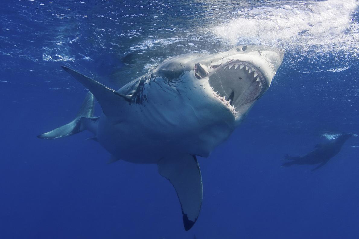
A great white shark. Image by Jim Abernethy, National Geographic.

A great white shark. Image by Jim Abernethy, National Geographic.

Great white sharks, a species over 16 million years old, are one of the most feared animals on Earth.They’re quite frightening; lurking in the ocean with their massive torpedo-like bodies, dagger-like teeth, and soulless, beady eyes. It’s safe to say the movie “Jaws,” is in part responsible for this fear. Let’s face it, they tend to get a bad rap, but sharks aren’t the mindless killing machines we perceive them to be.

Sharks play an essential role in the ocean’s ecosystem by keeping the food web in balance. They are top predators in the sea - a keystone species. Sharks maintain fish populations by eating them. Those fish then eat smaller fish, which eat even smaller fish, etc., all the way down the food chain. If sharks went extinct, the entire composition of the food web would shift and cause a top-down trophic cascade. The need for shark conservation has grown as the demand and exploitation rate of sharks have increased. Fishers kill millions of sharks every year for the Chinese delicacy: shark fin soup.

Every winter, in the North Pacific Basin, hundreds of great whites migrate from the California and Baja California coasts to a subtropical gyre, nicknamed the White Shark Café. This congregation area is located halfway between Hawaii and Baja California. Scientists are unsure why these sharks gather here. Maybe they’re socializing over a hot latte. More than likely, the sharks are meeting in this location to eat or mate.

At the Café, male sharks perform a strange, mysterious behavior of diving up and down continuously to approximately 150 ft. What is the purpose of this behavior? With the goal of gaining more knowledge, the Monterey Bay Aquarium Research Institute (MBARI) and other researchers are attaching camera tags to the sharks’ dorsals to record their diving conduct while they’re at the Café. MBARI has produced a neat video clip about the camera tags, available to view on YouTube.

On Feb 22nd, Europa started swimming through the southern outskirts of the Café, and she is still within the sharks’ migratory route. So far we’ve been fortunate a shark hasn’t chomped on her and obliterated all our data (keeping our fingers crossed)! Also, ship traffic has started increasing as Europa swims further into the Baja California Seamount Province (BCSP). All of this makes her more vulnerable and increases her risk.

Europa is currently surveying a few more seamounts in the BCSP. Then, she’ll start her trek home and continue to collect data. As she heads to Hawaii, we’ll want to keep her at low-risk by steering her south of the Café. Once we approach the Big Island where there’s more ship traffic, we’ll decide the best path into port to prevent a collision. So far, we’ve been able to steer away from any critical danger. We hope to keep it that way!


For a look back at Europa's prior journeys, check out our MAP and the Sea Surface Temperature (SST).

Aloha!

Subscribe to our blog

Mountains in the Deep Sea

A seamount is an underwater sea mountain formed by plate tectonics and volcanic activity. Seamounts form near the boundaries of tectonic plates and hotspots (Image 1). Plates force ocean and crust to descend towards Earth’s hot interior as they converge and collide near subduction zones. Here, the crust melts and forms into magma. The magma then returns to the surface as it buoyantly rises and fills in the gaps where plates diverge along mid-ocean ridges.

Image 1. This image from the Scientific Library Online displays a range of mapped seamounts. Scientists have only explored a small percent of these seamounts.

Image 1. This image from the Scientific Library Online displays a range of mapped seamounts. Scientists have only explored a small percent of these seamounts.

Earth’s crust is rich in silica. When it subsides, it makes the magma near subduction zones more viscous. Think of honey. Honey is extremely thick and sticky because it has a high silica content. The magma is also high in gases, including water vapor, and carbon and sulfur dioxide, that come from the ocean, soil, and rocks. Viscous substances don’t release gases quickly, so they accumulate in the magma chamber. As the gases increase, the pressure increases and magma explodes through the seafloor. The thick magma builds on the surface of the sea floor and cools rapidly, forming steep mounts. Isolated regions of magma called hotspots also create seamounts.

Seamounts are known to be diverse ecosystems. Vital nutrients are brought in by strong ocean currents and the process of upwelling (Image 2). Upwelling occurs when the wind blows across the ocean’s surface and pushes water away, allowing water to emerge from beneath the surface to replace it, along with nutrients from the deep, cold depths. The pressure of the ocean creates friction along the seamount walls, forcing the nutrients to rise through an eddy (Image 3).

Image 2. This image from NOAA demonstrates the process of upwelling.

Image 2. This image from NOAA demonstrates the process of upwelling.

Image 3. This image is a schematic drawing from Aliza Vinzant, illustrating a seamount ecosystem. The upward arrow on the left side represents the upwelling current, the whirlpool on the right side illustrates the eddy.

Image 3. This image is a schematic drawing from Aliza Vinzant, illustrating a seamount ecosystem. The upward arrow on the left side represents the upwelling current, the whirlpool on the right side illustrates the eddy.

Nutrients, such as nitrates and phosphates enable the growth of phytoplankton, which are microscopic algae that compose the basis of the marine food web and provide sustenance for a wide range of creatures. Seamounts home a variety of corals, sponges, anemones, mollusks, crustaceans, bivalves, echinoderms fishes, and many more organism. Furthermore, they provide resting and feeding areas for migratory species, such as sperm whales, sea turtles, seabirds, and sharks. Hence, we are exploring the hypothesis that humpback whales may be congregating around seamounts too.

The biodiverse seamount ecosystems are unique because they contain endemic, fragile, long-lived, and rare species. However, this makes the ecosystems vulnerable. Commercial fishers are attracted to these locations because of the seafood abundance. As anthropogenic activity increases, scientists are recognizing the need to understand better the ecology of seamounts and factors that are impacting these sensitive benthic communities.

In a study called, “The Structure and Distribution of Benthic Communities on a Shallow Seamount (Cobb Seamount, Northeast Pacific Ocean),” by Preez et al., they conclude that the majority of seamount communities are at risk from anthropogenic disturbances. They are also at risk from ocean acidification and are refugia for biota from marine climate change. As risk increases, conservation and management efforts also increase. However, efforts will be at a disadvantage if researchers do not collect enough baseline data. NOAA and other organizations are using unmanned underwater vehicles to conduct imagery surveys with the purpose of better understanding the ecology of benthic communities (Image 4).

Image 4. This picture by NOAA depicts image mapping of a seamount.

Image 4. This picture by NOAA depicts image mapping of a seamount.

Europa is past the second seamount and is on her way to a chain of seamounts. At the second seamount, we received an audio snippet that sounded like an odontocete, or toothed whale.  We’ve sent the audio to Dr. Jim Darling and Dr. John Ford (a killer whale specialists) for further analysis.

Stay tuned for more updates and a post about the Shark Café in our next blog!


For a look back at Europa's prior journeys, check out our MAP and the Sea Surface Temperature (SST).

Aloha!

Subscribe to our blog

Commotion in the Ocean

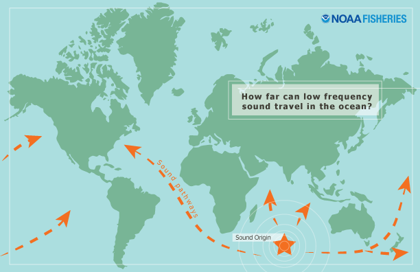
Visibility in the ocean is relatively weak, especially at a depth of 400+ meters, making vision rather useless in the deep sea where whales reside. Sunlight doesn’t travel very far into the ocean. However, acoustic vibrations travel faster and farther in water than they do on land (Image 1). Therefore, sounds are valuable tools in deep, dark environments where whales use their ears as their eyes.

Image 1: An image by NOAA. A visual representation how far low-frequency sounds travel through the ocean.

Image 1: An image by NOAA. A visual representation how far low-frequency sounds travel through the ocean.

Animals in marine environments rely on sound for basic survival needs. For example, baleen whales, which are the largest of marine mammals (including humpback, blue, fin, right, and gray whales, etc.) emit long, low-frequency sounds ranging from 7Hz to 22kHz that travel long distances across the ocean. Baleen whales also travel long distances making periodic migratory trips from their feeding grounds to their breeding grounds. Thus, scientists hypothesize that baleen whales use low-frequency sound in part to aid in navigation and long-distance communication.

The ocean is already a naturally loud environment, and humans have significantly increased that noise level. Anthropogenic noise pollution (such as ship traffic) obscures animals' communication, and could potentially have adverse effects on marine life; especially baleen whales (Image2). Although, considerable scientific uncertainty remains. Many factors influence the degree of impact, including multiple characteristics of the sound, and the animal. Potential impacts include behavior alternation, temporary hearing loss, and various communication interferences (Image 3).

Image 2: An image by the University of Rhode Island. A visual representation (in frequency (Hz)) of how anthropogenic noises interfere with marine mammals. Baleen whales' sounds are masked by seismic, ship traffic and bubbles & spray noises.

Image 2: An image by the University of Rhode Island. A visual representation (in frequency (Hz)) of how anthropogenic noises interfere with marine mammals. Baleen whales' sounds are masked by seismic, ship traffic and bubbles & spray noises.

Image 3: An image by SSPA. A visual representation of anthropogenic noise interference with marine animals.

Image 3: An image by SSPA. A visual representation of anthropogenic noise interference with marine animals.

Scientists study sounds and their relationship with the environment over a wide range of scales (both spatial and temporal) via a new science called ecoacoustics. They investigate sounds to understand their evolution, functions, and properties under environmental stressors and changes. Sounds are used as tools to monitor ecological factors, such as biotic and abiotic relationships, and animal behavior, diversity, abundance, distribution, etc.

Using hydrophones to record marine acoustics have helped scientists gain knowledge, and a better understanding of the ocean and how we’re affecting it. We are proud to say our Wave Gliders (WGs) don’t produce noise that’s harmful to whales or other marine life. So far, we think WGs do not deter animals: fish aggregate around them, birds rest on them, whales swim near them, and dolphins bow ride them. The WG has revolutionized the way we collect data and monitor the ocean. The hydrophone we attached to Europa is gathering acoustic data 24/7 through which we hope to gain more knowledge and understanding of the sea. Additionally, we expect our data will create a baseline, and contribute to marine ecoacoustics, as well as, support conservation efforts and the management of marine resources.

Europa Update:

Europa is approaching our second seamount; we’re within 25 miles! Stay tuned for a seamount update, the ecology of seamounts, and the habitats they provide in our next blog.


For a look back at Europa's prior journeys, check out our MAP and the Sea Surface Temperature (SST).

Aloha!

Subscribe to our blog

A Whale of a Tale

We have a whale of a tale to tell you! Whale actually, we just want to tell you about our HUMPACS presentation at Whale Tales. Every year since 2016, whale lovers from around the world gather at the Whale Tales event on Maui. Hosted by Whale Trust (our HUMPACS partner), this event allows world-renowned scientists, photographers, filmmakers, and conservationists to share and discuss their work and latest research with the public through captivating talks, receptions, and exciting whale watches. This year’s presenters were terrific.

On February 16th, our HUMPACS project manager and VP of Hawaii Operations, Beth Goodwin, flew over to Maui to present our HUMPACS project with Dr. Jim Darling (Image 1). Beth has given talks at Whale Tales a couple of times within the past few years on JRF Wave Gliders and her humpback research. We are honored to participate in this memorable event, and it’s a great way to impart current scientific discoveries and research to the public.

Image 1. Beth Goodwin and Dr. Jim Darling presenting HUMPACS. The slide consists of our team members, Murray (left), and Adam (right), assembling Europa.

Image 1. Beth Goodwin and Dr. Jim Darling presenting HUMPACS. The slide consists of our team members, Murray (left), and Adam (right), assembling Europa.

In the U.S, a significant gap in opinion exists between the general public and scientists on a wide range of science-related topics. The difference is partly due to the lack of STEM education in grades K-12, which creates a population that is scientifically illiterate. Science can be hard to understand if one is not familiar with the scientific method and the language scientists use, thus resulting in mistrust and misunderstanding of scientific data. Therefore, communicating scientific matters to the public can be a challenge

Whale Tales is an event that contributes to bridging this gap because presenters convey their research via engaging media presentations, storytelling (tales), and discussions from which the public can gain knowledge that’s been modified to be intelligible. Additionally, the event creates a way for scientists to present their work to their colleagues and professional peers. This allows the scientists (and other presenters) to receive feedback on their research and engage in discussion, which enables them to improve their work.

After her presentation, Beth, and Dr. John Ford volunteered to be naturalists on one of the whale watches where they were able to share their knowledge about humpback flukes and photo identification (Video 1). It’s not a fluke that they saw so many whales! Humpback whales have unique pigment patterns on their flukes (tails). Researchers compare fluke pictures to identify individuals. In 2007, Cascadia Research completed the SPLASH Project, which compiled thousands of fluke photos from numerous researchers with the purpose of determining population size within the entire North Pacific basin. 

Video 1. Beth Goodwin and Dr. John Ford talking about humpback whales on a whale watch. Video by Bryan Berkowitz

In other news, On Feb 19th, Europa made her way to the first seamount! Once there, we had her swim in a circle around the seamount for a few days while we listened to audio snippets. We’ve heard some unusual noises, but nothing that confirms the presence of humpback whales. So, we will persist forward. Our next target is a chain of seamounts within the outskirts of the Baja California Seamount Province (Image 2). It’s approximately 660 nautical miles away and will take about 18 days to arrive; between March 10th-13th. 

Image 2. Our next target: a chain of seamounts.

Image 2. Our next target: a chain of seamounts.

On Feb. 21st, Oceans Deeply interviewed Beth and wrote a compelling article about our mission. This media outlet is an excellent source for current ocean discoveries, and they’ve written numerous articles about Wave Gliders. 

Stay tuned for more updates!


For a look back at Europa's prior journeys, check out our MAP and the Sea Surface Temperature (SST).

Aloha!

Subscribe to our blog

Building our Acoustic Payload

Searching for humpback whale vocalizations in the middle of the Pacific Ocean is sort of like searching for a needle in a haystack. So, how do you search for a needle in a haystack? You build a sophisticated audio payload and keep your fingers crossed. Luckily our needle is a loud one!

The construction of our acoustic payload required a lot of software and hardware engineering because we wanted our hydrophone to detect whales from miles away, and keep data from being lost in case of an accident. Consequently, we acquired a “smart” digital hydrophone (HP) called the Ocean Sonics icListen 200 kHz, which can record a wide range of frequencies and target most cetaceans (Image 1).

Image 1. Ocean Sonics Hydrophone

Image 1. Ocean Sonics Hydrophone

Many mishaps could occur to a dangling HP in the middle of the ocean, hence we attached the HP to Europa’s sub to ensure we wouldn’t lose it to entanglement or predation (Image 2). However, the self-noise of the sub is relatively loud, and we found that it interfered with the acoustic sampling. Therefore, we embarked on a design to decouple as much of the sub noise as possible and enlisted the help of an acoustician, Mike Holt, who has built similar devices his entire career. He helped us make a mount that would be durable but not too heavy, biofoul resistant for the several months mission and allow sound transference to occur. To construct this, we used a thick-walled 3” type K copper pipe, which is an excellent biofoul deterrent and provides mounting strength. We mounted it to the center of the sub so that it did not add drag or change the pitch of the sub (Image 3).

Image 2. Pelagic white tip shark chasing an entangled Wave Glider

Image 2. Pelagic white tip shark chasing an entangled Wave Glider

Image 3. Hydrophone mounted to center of sub

Image 3. Hydrophone mounted to center of sub

To mask the mechanical noise, Mike first designed an inner casing tube out of low-density polyethylene into which the HP would slide. To keep it from hitting the bottom or the sides we manually cut 15 donuts of 10 pores per inch by 0.75” thick polyurethane open cell foam to encase the HP. We then sealed the tube and filled it with medical grade castor oil, which is well matched to the impedance of seawater. After testing it for leaks, we slid the inner casing into the outer copper pipe modified with 250 drilled holes. The holes enabled the interference to be no greater than 12th lambda of the highest frequency of interest (Image 4).

Image 4. Murray and Beth building hydrophone casing

Image 4. Murray and Beth building hydrophone casing

Overall, the entire process was painstaking but worth the effort to boost our chances of finding our needle in a haystack.

For question, please email HUMPACS@jupiterfoundation.org


For a look back at Europa's prior journeys, check out our MAP and the Sea Surface Temperature (SST).

Aloha!

Subscribe to our blog

Europa’s Super Blue Blood Moon Photos

The Super Blue Blood Moon was a sight to see! Don’t you think so? Many awoke in the early morning hours to watch the moon turn red, and those who missed it were able to view stunning photographs of it on the internet. Amazing photographers from all over the world captured shots of this ‘once in a blue moon’ event.

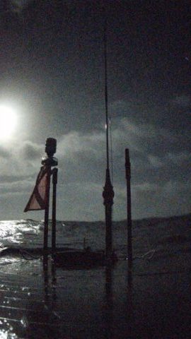
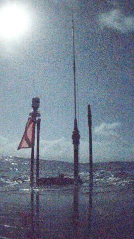
On January 30th, from 6:15 p.m. to 7:15 p.m. HST with location coordinates of 18.99°N, 149.50°W, Europa was able to capture a photo series of the moon rising! She wasn’t able to catch the moon when it turned red because it was too high in the sky. We only had a short window (an hour) of when the moon was in the camera view. Even so, the pictures are remarkable, as they are likely the only pictures in the world captured that night by an autonomous ocean vehicle (see image series below). In the first photo of the series, it was still light because the sun had just set. As the moon rose, the images became darker but then lightened again as the moon rose further into the sky because of its brightness.

To obtain this image series, we calculated the trajectory, angle, and rising time of the moon relative to Europa's location. We then steered Europa to face the right direction where the camera could capture the moon rising in front of her. During that hour (starting at 6:15) we set the camera payload to take a photo every 15 minutes, totaling five pictures.

Who knows what will be taking pictures of the next Super Blue Blood Moon on January 31, 2037!

For questions, please email HUMPACS@jupiterfoundation.org

Mahalo!


For a look back at Europa's prior journeys, check out our MAP and the Sea Surface Temperature (SST).

Aloha!

Subscribe to our blog

Deploying Europa

On January 15, 2018, we successfully deployed our Wave Glider (WG), Europa, to embark on our most ambitious mission to date, HUMPACS (Humpback Pacific Survey). It was a beautiful day when we launched Europa; the wind was relatively light, and the sea state was calm. Conditions such as these enable a smooth process of loading and unloading WGs from our 32 ft boat, the May Maru.  

Our team worked for a year to prepare Europa's payloads and ensure her success during the three-month mission at sea. Thus, we celebrated the triumph by pouring a bottle of champagne over Europa before letting her swim away (see video below). Please note that we drank what was left of the bottle after working hours! Once deployed, a school of dolphins joined Europa; bow riding and spinning while escorting her out to sea (see video below). We perceived this as a good omen to our cetacean mission!!! 

We deployed Europa off Puako, the northwest coast of Hawai'i Island. As she made her way around South Point, the southernmost tip of the Island (and the USA), strong currents from a big winter swell kept pushing her off course. This was a little discouraging because Europa was only a few days into her mission and we didn't want her to go astray. Nevertheless, Europa pulled through and she’s making impressive progress, averaging ~1.5 knots. Europa is scheduled to reach her first seamount anywhere between February 18th-21st. Track Europa's journey here.

Europa is transmitting multiple data types to us via satellites, in real-time. Some of the data are available to view in our Data Portal. We just assembled a graph of daily sea surface temperature (SST) means that will be updated periodically to display recent data. An additional SST logger called a HOBO, which is more precise, is attached to Europa but its data can't be accessed until the mission is complete. Stay tuned for more updates!

For questions, please email HUMPACS@jupiterfoundation.org

Mahalo!


For a look back at Europa's prior journeys, check out our MAP and the Sea Surface Temperature (SST).

Aloha!

Subscribe to our blog