Seamounts

Europa's NOT Drunk!

You may have noticed that Europa has been bouncing around a bit more than it did on HUMPACS East. Well don’t worry…it’s intentional!

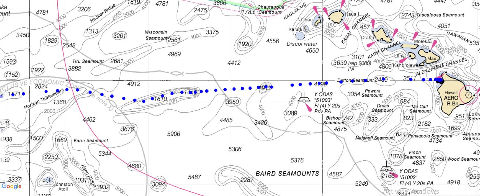
The general path that Europa is following goes along 20oN latitude.

The reason that it is not going in a straight line is because there are numerous seamounts and guyots (aka tablemounts) that we are having it navigate over on it’s way to the Mariana Trench.

Seamounts are basically underwater mountains that are at least 1,000m tall. They do not actually reach the ocean’s surface. Guyots are seamounts that did, at one time, rise above the ocean’s surface, but then eroded away, flattened out, and eventually sunk back down underwater.

Why does all of this matter?

Well, since Europa is basically a very small fish in a very big pond, we need to strategically look for these humpback whales. Even though most of the time the tops of these seamounts and guyots can be found many hundreds, if not thousands, of meters below the ocean’s surface, they are actually great producers of marine ecosystems. That makes us think that we might have a better shot at stumbling upon some humpbacks in those areas, as opposed to simply out in the middle of an even deeper ocean.

There has been some research to support the statement that humpbacks seem to frequent seamounts and guyots, though the exact reason why hasn’t been determined.

The leading theories are that the landmarks serve as resting and/or feeding areas, points for navigation, and even meeting grounds (source: PubMed Central®).

Maybe they’re sharing different versions of their song? At the end of the day, we don’t really know why…yet!

If you’d like to dive a little deeper into the science and evolution of a seamount, check out our blog post Mountains in the Deep Sea.

Figure 1: Europa’s path on a nautical chart. Europa is currently traveling from East to West, and navigating over many different seamounts and guyots. (Depths are in meters).

Figure 1: Europa’s path on a nautical chart. Europa is currently traveling from East to West, and navigating over many different seamounts and guyots. (Depths are in meters).

 
Figure 2: Zoomed in image to show more detailed depths of the Horizon Tablemount that Europa traveled over Jan 16-19, 2019.

Figure 2: Zoomed in image to show more detailed depths of the Horizon Tablemount that Europa traveled over Jan 16-19, 2019.

Figure 3: Europa circling a particular seamount. We will have Europa do this from time to time to search a little more for humpbacks in areas we suspect them to be.

Figure 3: Europa circling a particular seamount. We will have Europa do this from time to time to search a little more for humpbacks in areas we suspect them to be.

If you check out the HUMPACS page, you’ll notice that from January 16-19 Europa was cruising over the Horizon Tablemount. In another two or three weeks, Europa should be traveling around the HIG Guyot. This particular guyot is of note to us here in Hawaii because it was actually discovered about 37 years ago by the “Kana Keoki” research vessel, and named after the Hawaiian Institute of Geophysics (source: Marineregions.org).

So, for those of you that were wondering, and dare we say concerned, about Europa’s up and down path…worry no more! Europa is doing exactly what we want it to do, and we’re collecting lots of great data that we look forward to sharing later on.

Until then, keep checking in and watching Europa as it makes it’s way West across the Pacific Ocean.

Also, check out our live audio stream of the humpback whales that are swimming around Puako, HI right now!

Aloha!


For a look back at Europa's prior journeys, check out our MAP and the Sea Surface Temperature (SST).

Aloha!

Subscribe to our blog

Mountains in the Deep Sea

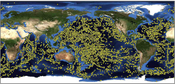
A seamount is an underwater sea mountain formed by plate tectonics and volcanic activity. Seamounts form near the boundaries of tectonic plates and hotspots (Image 1). Plates force ocean and crust to descend towards Earth’s hot interior as they converge and collide near subduction zones. Here, the crust melts and forms into magma. The magma then returns to the surface as it buoyantly rises and fills in the gaps where plates diverge along mid-ocean ridges.

Image 1. This image from the Scientific Library Online displays a range of mapped seamounts. Scientists have only explored a small percent of these seamounts.

Image 1. This image from the Scientific Library Online displays a range of mapped seamounts. Scientists have only explored a small percent of these seamounts.

Earth’s crust is rich in silica. When it subsides, it makes the magma near subduction zones more viscous. Think of honey. Honey is extremely thick and sticky because it has a high silica content. The magma is also high in gases, including water vapor, and carbon and sulfur dioxide, that come from the ocean, soil, and rocks. Viscous substances don’t release gases quickly, so they accumulate in the magma chamber. As the gases increase, the pressure increases and magma explodes through the seafloor. The thick magma builds on the surface of the sea floor and cools rapidly, forming steep mounts. Isolated regions of magma called hotspots also create seamounts.

Seamounts are known to be diverse ecosystems. Vital nutrients are brought in by strong ocean currents and the process of upwelling (Image 2). Upwelling occurs when the wind blows across the ocean’s surface and pushes water away, allowing water to emerge from beneath the surface to replace it, along with nutrients from the deep, cold depths. The pressure of the ocean creates friction along the seamount walls, forcing the nutrients to rise through an eddy (Image 3).

Image 2. This image from NOAA demonstrates the process of upwelling.

Image 2. This image from NOAA demonstrates the process of upwelling.

Image 3. This image is a schematic drawing from Aliza Vinzant, illustrating a seamount ecosystem. The upward arrow on the left side represents the upwelling current, the whirlpool on the right side illustrates the eddy.

Image 3. This image is a schematic drawing from Aliza Vinzant, illustrating a seamount ecosystem. The upward arrow on the left side represents the upwelling current, the whirlpool on the right side illustrates the eddy.

Nutrients, such as nitrates and phosphates enable the growth of phytoplankton, which are microscopic algae that compose the basis of the marine food web and provide sustenance for a wide range of creatures. Seamounts home a variety of corals, sponges, anemones, mollusks, crustaceans, bivalves, echinoderms fishes, and many more organism. Furthermore, they provide resting and feeding areas for migratory species, such as sperm whales, sea turtles, seabirds, and sharks. Hence, we are exploring the hypothesis that humpback whales may be congregating around seamounts too.

The biodiverse seamount ecosystems are unique because they contain endemic, fragile, long-lived, and rare species. However, this makes the ecosystems vulnerable. Commercial fishers are attracted to these locations because of the seafood abundance. As anthropogenic activity increases, scientists are recognizing the need to understand better the ecology of seamounts and factors that are impacting these sensitive benthic communities.

In a study called, “The Structure and Distribution of Benthic Communities on a Shallow Seamount (Cobb Seamount, Northeast Pacific Ocean),” by Preez et al., they conclude that the majority of seamount communities are at risk from anthropogenic disturbances. They are also at risk from ocean acidification and are refugia for biota from marine climate change. As risk increases, conservation and management efforts also increase. However, efforts will be at a disadvantage if researchers do not collect enough baseline data. NOAA and other organizations are using unmanned underwater vehicles to conduct imagery surveys with the purpose of better understanding the ecology of benthic communities (Image 4).

Image 4. This picture by NOAA depicts image mapping of a seamount.

Image 4. This picture by NOAA depicts image mapping of a seamount.

Europa is past the second seamount and is on her way to a chain of seamounts. At the second seamount, we received an audio snippet that sounded like an odontocete, or toothed whale.  We’ve sent the audio to Dr. Jim Darling and Dr. John Ford (a killer whale specialists) for further analysis.

Stay tuned for more updates and a post about the Shark Café in our next blog!


For a look back at Europa's prior journeys, check out our MAP and the Sea Surface Temperature (SST).

Aloha!

Subscribe to our blog